
Climbing Mountains and Growing Older

For the past several summers now, my family has left the desiccated expanses of Texas and headed north to the sublime mountains of Colorado. Just before the start of the school year, we’ll rent a cabin at the YMCA of the Rockies, a vacation and conference destination surrounded on three sides by Rocky Mountain National Park. As befits a family vacation, most of our time is spent together. Through trial and error, we’ve determined that the girls are good for up to eight miles of hiking. Clara can go further, but the altitude starts to make things unpleasant for her at about 11,500 feet. While there’s plenty to see within that distance and below that elevation, at some point I negotiated permission to take a half-day to head off on my own more strenuous adventure. As much as I enjoyed exploring Colorado with my family, I came to appreciate spending time alone with my thoughts in the majestic beauty of the Front Range. Each year these solo hikes became a bit longer and climbed a bit taller. Although not initially identified as a goal, I eventually decided I wanted to attempt to summit Longs Peak.
At 14,259 feet, Longs is not the tallest mountain in Colorado (Mount Elbert, 14,439 feet) and it’s well over a mile shorter than the tallest mountain in the United States (Denali, 20,310 feet). It is, however, the tallest summit in Rocky Mountain National Park. There are “technical” routes that lead to the summit of Longs via its diamond-shaped sheer east face, but I am decidedly not a technical mountaineer. Luckily, the so-called “Keyhole Route” seemed potentially achievable for a flatlander like me. Fourteen miles in length with 5,100 feet of vertical elevation gain, it would be further and higher than I had ever hiked before. That said, it seemed to be an attainable goal for which I could train and prepare. And since I’m reaching the age where my physical abilities are generally trending downward, climbing Longs Peak seemed to be something I should try sooner rather than later.
And so earlier this year I traded my running shoes for a pair of approach boots. Building up to hiking 14 miles proved easy enough and as there are no mountains to climb in south-central Texas, a monthly membership at a local Planet Fitness provided access to a stair machine upon which I was able to approximate climbing 350 floors or 5,100 feet.
Of course, the one thing I could never simulate in Texas was hiking 14 miles while ascending 5,100 feet. Although I seem to be less susceptible than the rest of my family to the thin air found at higher elevations, its impact on my already limited physical and mental abilities would be real. I could schedule the hike late in our stay in Colorado in order to give my body some time to acclimate, but the altitude would remain the biggest variable of the attempt. That and the fact that the hike up Long’s Peak would be more than just a hike.
According to the Yosemite Decimal System, the Keyhole Route up Longs Peak is classified as a “Class 3” climb. This means climbers could expect:
…scrambling with increased exposure. Handholds are necessary. A rope could be carried. Falls could easily be fatal…
I’ve been on plenty of hikes where one could, theoretically, off oneself by carelessly wandering off the edge of a cliff or accidentally bashing one’s head against a sharp rock, but the descriptions of the various sections of the Keyhole Route explicitly stated how things could turn deadly.
Part of the issue was the remote nature of the route: if you run into trouble and fail to summit a mountain three-quarters of the way through the climb, you still have to descend that same distance before you’re out of the literal and figurative woods. Injuries are also far more likely during a descent because you’re more fatigued (and because gravity and momentum combine to increase speed and the likelihood of losing your footing). Add to that the altitude, the potential extremes of weather found at that altitude, and the fact I would be operating at the edge of my physical and technical abilities, it seemed wise to not attempt Longs Peak alone. After some research, I decided to hire a mountain guide who would provide the technical knowledge and judgment I knew I lacked. After some back-and-forth emails about whether or not I was getting in over my head, a deposit was paid and a date was set for Friday, August 5th.
We began to make our way to Colorado a little over a week before that Friday. The first day of driving took us as far as El Paso. From there we made our way up through the White Sands and the Sangre de Christo Mountains of New Mexico before eventually crossing the border into Colorado. After an unplanned stop at an urgent medical clinic in Leadville to deal with a pinched nerve Clara had acquired along the way (see earlier note about physical abilities trending downward), we eventually made it to our cabin just outside of Estes Park. As a family, we shot some arrows at the archery range, fed some chipmunks at the top of the Aerial Tramway, and even climbed a mountain (Deer Mountain, 10,013 feet). While locals complained of the heat (the highs were in the low seventies), it felt absolutely refreshing compared to the triple-digits we had left behind in San Antonio.
The forecast looked good as the day of the climb neared: Clear skies could be expected in the morning with a chance of thunderstorms later in the day. Afternoon precipitation was not uncommon and we experienced some sort of it most days we were there. As warm, moist air is pushed up and over the Rockies in the morning hours, it condenses and falls as rain or snow depending on the temperature. As you might guess, an exposed alpine summit is not a great place to be during a thunderstorm, and so climbers are encouraged to be off the mountains well before noon. Given the length of the Keyhole Route and the time required to reach its summit, my guide recommended meeting to start our climb at 1:00 in the morning.

brochure courtesy NPS
The Trailhead
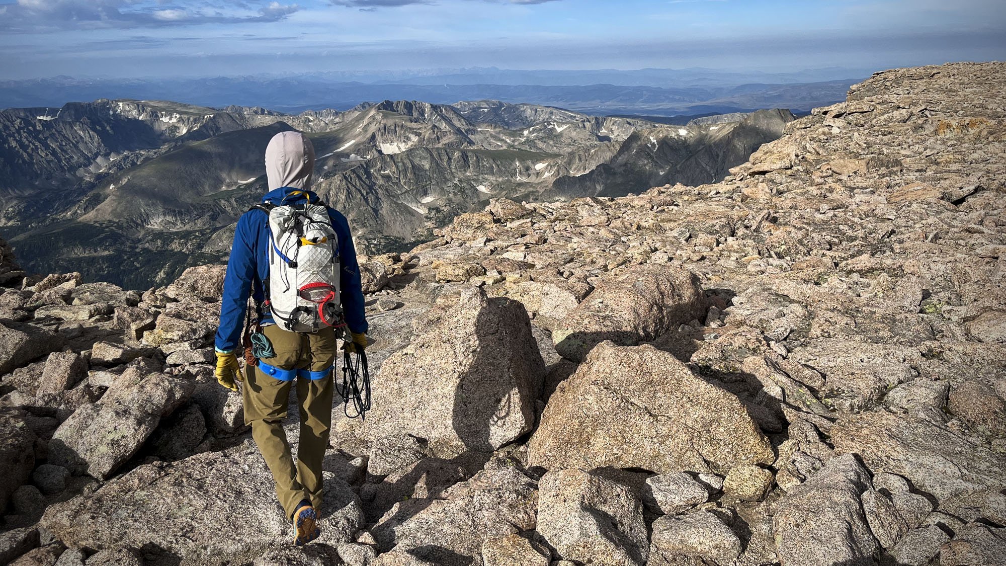
I awoke at 11:45 p.m. on the evening of August 4th which allowed me to be on the road by 12:15to drive the 23 miles from our cabin to the Longs Peak Trailhead. There I met my guide, Nathan, in the surprisingly full lot at the Longs Peak Trailhead. We exchanged pleasantries and he provided me with a climbing harness and helmet. After some last-minute rearranging of my pack, we started started the ascent. According to my watch, it was 1:15 a.m. and we were at 9,534 feet.
One obvious downside of starting a hike in the middle of the night is that so much of it will then occur in the dark. I knew the trail was taking us along a stream and through a forest, but because the moon had already set behind the invisible mountain in front of us, it was impossible to see much of anything beyond the few yards of illumination provided by our headlamps.
And so it went for the first five-or-so miles and the first 3,000-or-so feet of elevation change. As tedious as hiking in the dark might sound, those first few hours flew by. Nathan and I passed the time by getting to know one another. Trained as an engineer, he had engineered himself a life where he got paid to go on amazing hikes in beautiful locations. But as a mountain guide, he also faced unique challenges. For one, while he is paid to help someone climb a mountain, in order to do that safely, he needs to understand the physical and technical limitations of a client he has just met who may or may not be self-delusional about their mountaineering abilities. I tried to be as honest in describing my (relatively tame) past climbs and revealed my (relatively low) tolerance for risk. Of course, all this was done while engaged in a vigorous hike through increasingly higher altitudes. More than anything I was saying, Nathan was probably paying attention to how heavily I was breathing during this, the easiest part of the route.
In this part of Colorado, trees find it increasingly difficult to grow past 11,500 feet (which, as mentioned earlier, is the same elevation my wife finds it increasingly difficult to hike past). At around this altitude, a dense forest of spruce and fir will transition to a sparse tundra of low grasses and sedges. In the daylight, this line can be remarkably well defined: one moment you’re hiking in a forest and then suddenly you find yourself exposed on the side of what looks and feels like a real mountain. In the dark of the approach to Longs Peak, that transition came and went without my knowledge.

The Boulderfield
After several hours of hiking in the dark, we finally arrived at the base of the Boulderfield. As its name implies, this is a field of large boulders. I had traversed terrain like this before and although not difficult or dangerous per se, you do need to be intentional about where you’re placing your feet. Smaller boulders can shift under your weight and while losing your balance might not be catastrophic, falling on sharp granite is still something to be avoided.
Whereas the trail up to that point had been well defined, there is no single way to traverse a field of boulders. You know where you need to get to, but there are multiple ways of doing that. In looking at the path recorded by my GPS tracker, my route up the Boulderfield diverged significantly from my route down it.
A critically important factor defining hiking in Texas is hydration. Especially in the summer, the distance you can go is limited by the amount of water you can carry. With this mindset, I started my climb up Longs Peak with almost a gallon of liquid sloshing around on my back. Two liters of water were in a "hydration bladder”, one was in a “backup” Nalgene bottle, and the rest was in a prepackaged electrolyte sports drink. All that added about up to about eight-and-a-half pounds of extra weight. While this would obviously decrease as I drank it on my way up the mountain, it was an extra load I learned Nathan was not carrying. Because of his familiarity with the route, he knew where he could take out his combination water filter/flask and dip it into the crystal-clear water of a naturally flowing stream. There he could quench his thirst by drinking chilled water that had been a glacier only moments before.
We paused for a moment at the Boulderfield Campground. In order to avoid a 1:00 a.m. departure, some choose to hike up to this point and camp there overnight before summiting Longs Peak the following morning. Sleeping on boulders did not seem pleasant, and I was glad to have opted to attempt the summit in a single day. Yes, it was an early morning, but it allowed us to achieve our goal of making it through the Boulderfield and up to the Keyhole by sunrise.

The Keyhole
About midway along the jagged ridge between Storm and Longs Peak sits the geologic feature that gives the Keyhole Route its name. When viewing the mountain from a distance, the Keyhole is barely visible and certainly not its most identifiable feature. Seen up close, the cantilevered rock formation is striking.
Any significant rock overhang is impressive as the ability to occupy space under solid rock is both unusual and unnerving, but the Keyhole’s form is singularly dynamic. Its knife-like form cuts through the sky. Its serrated surface feels as if it is the result of the mountain’s extreme environment even as it stands in defiance of those same forces. The narrow pass underneath this landmark also acts as a visual and physical funnel. The spatial expanse of the mountain—along with the temporal expanse it had taken us to climb it up to this point— all felt compressed into a single explosive point of inflection.
The 5.5 miles leading up to this point felt analogous to many of the longer hikes I had been on before. Yes, it was long and yes, I had sweated through my base layer (in retrospect, I should have ditched my outer layer earlier, but I kept expecting the temperature to drop and/or for the wind to increase), but other than the hike occurring in the dark, the beats of the Keyhole Route so far felt familiar.
This would change immediately after we passed through the Keyhole whose rough, oval-shaped opening acted as a physical and symbolic transition to a completely different experience. The sun had just risen at 6:03 a.m. when we passed through the Keyhole from the east to the west face of the mountain. Now in its shadow, the close views of the Boulderfield were replaced by the distant views of the ridge of mountains two miles away on the other side of Glacier Gorge.

The Ledges
The view was not the only thing that changed. On the other side of the Keyhole, all the “exposure” I had read about suddenly felt very real. The west face of the mountain consists of a series of horizontal shelves that create a slope considerably steeper than the east face. Although I didn’t feel as if I was about to tumble off the edge at any moment, I did sense the heightened consequences of if I were to do so. The route also suddenly felt much more crowded as a constant stream of climbers flowed through the Keyhole. I could have followed their lead as they turned and made their way to the left, but the way forward felt suddenly unclear. It may have been the altitude or the simple fact I had reached the limit of my comfort zone, but I felt overwhelmed. If I had been attempting this climb on my own, I probably would have turned back at this point.
But I wasn’t alone. Before passing through the Keyhole, Nathan had me don my helmet and a climbing harness. After attaching a safety line, he had me turn to the right and scramble out onto a granite pinnacle (something I definitely would not have felt comfortable doing on my own and/or without a safety line). After snapping a photo with his camera, Nathan and I unclipped ourselves from one another and joined the line of other climbers heading along the part of the route known as the Ledges.
While leaning towards the rocks to my left to avoid the steep drop-off to my right, the narrow path known as the Leges proved to be not quite as precarious as it first seemed. Even if a lethal fall might have been consistently possible in a way it normally wasn’t, I rarely felt unsafe or that such a fall was imminently likely. When it was—I am reminded of an unfortunately-placed boulder one crosses by stepping onto a steel rod cantilevered out over oblivion—Nathan would have already anticipated the situation and attached the safety line.
Even without signage or cairns, a trail can usually be followed just by locating the line of disturbed ground where others have walked before you. This, however, is not possible on the granite face of a mountain. In order to keep climbers on the safest route, the National Park Service painted a series of red and yellow bullseyes to mark the way. We followed these markers along a mostly level path before we found ourselves at the base of the Trough.

The Trough
If the Ledges were flat but exposed, the Trough was steep but protected. Ascending the 600-foot-deep gully was like the Boulderfield in that there was no singular path through it. There were likewise no painted bullseyes to follow as we turned left again and began to our scramble. That said, because the pitch was steeper and the rocks were smaller, it felt more treacherous. Careful foot placement became critical both to avoid twisting an ankle and to avoid dislodging rocks that would rain down on climbers below.
As we ascended the Trough, the altitude began to noticeably impact my progress. Because of the exertion involved, I often found myself out of breath as we climbed past 13,500 feet. I ended up taking a large number of photos of the Trough because the act of pulling out my phone and snapping a photo gave me a few extra seconds to gulp down a bit more oxygen.
I’d like to think this delaying tactic was believable as the view from the trough was impressive. One thing I would later notice about all my photos was how difficult it was to perceive the relative size of things. Without trees or other scale-giving clues, it was impossible to tell if a particular foreground element was a small rock or a boulder the size of a small car. In the photos taken in the Trough, fellow climbers helped communicate the vast scale of things.
Those fellow climbers also helped reassure me that everyone was out of breath. To be sure, we were being passed by a number of climbers who wore trail-runners as opposed to hiking boots and who seemed to be on a quick walk around the block as opposed to an arduous climb up a mountain. But most others, like me, had to focus on putting one foot in front of the other in order to continue plodding upwards.
Nathan, for his part, was infinitely patient with me and my slow rate of progress. This ascent up Longs Peak was his third one that week and I can’t say he ever appeared to be breathing heavily. With plenty of breath to spare, he chatted with other climbers as we passed them or as they passed us and proved to be a great resource for identifying the other mountain peaks rising around us or the glacial lakes pooling in the valley below us.

The Narrows to The Homestretch
After roping up once more near the top of the Trough to get over a particularly dicey chockstone, we took another left and found ourselves on the Narrows. Similar to the Ledges before it, this portion of the route required us to navigate a series of narrow ledges along a sheer face of granite. on the south face of the mountain. In doing so we were treated to a panoramic view of Rocky Mountain National Park’s Wild Basin.
Making one last left-hand turn put us at the base of the Homestretch. After passing through the Keyhole, we had circled around the summit 180 degrees and for the final ascent were now heading east back towards the distant trailhead. Compared to what came before it, this was a relatively straightforward scramble up the angled granite slab that guards the summit.
It should be noted that the only reason these last few hundred feet—or any other part of the climb—could be deemed “straightforward” was because of when our climb was occurring. The Keyhole Route is reliably free of ice and snow for only a few months between mid-June and mid-September, a window of time that just happened to coincide with when our family makes its annual trip to Colorado. Wet or icy conditions on the route (along with the extreme weather conditions associated with colder temperatures) would render the climb treacherous for all and impossible for me.
As it was, we had perfect weather. The clear skies allowed temperatures to rise only slightly as we ascended. Topographic funnels like the Keyhole and Trough can become dangerously windy, but on this day the winds remained calm. In the end, I did not need any of the extra layers—waterproof or otherwise—that I had packed.
Of course, I had no way of knowing that when I set out that morning. Like the rope Nathan would occasionally attach to the auto-locking carabiner on my borrowed harness, it accounted for an unknowable future and mitigated some of the risk associated with an undertaking that naturally carries with it some inherent danger. It didn’t eliminate the risk: a storm could have developed suddenly or a stumble could have occurred when I wasn’t roped to my guide. Heck, I could have hit an elk on the drive to the trailhead. But with the precautions that were taken (and with a little bit of luck), none of that happened.
Instead, Nathan and I climbed a mountain.

The Summit
Nathan and I exchanged high-fives as we rose out of the Homestretch. At approximately 7:40 a.m. on the morning of August 5th, 2022, we summited Longs Peak and I claimed my first “Fourteener.” I seriously doubt I would have made it without Nathan and I will be forever grateful for his assistance. I’d like to think he enjoyed the experience as well: As the saying goes, if you help someone to the top of the mountain, you arrive there, too.
The top of Longs Peak is a tilted plane that’s approximately the size of a football field. One corner is higher than the others, but there is no single point that clearly identifies itself as the actual summit. Were it not for the existence of a brass USGS marker (and the cadre of people posing for selfies nearby), I would have been unable to locate it on my own.
I downed a couple of peanut butter & jelly bagels I had packed into ziplock bags. Having spent the previous six-and-a-half hours in my backpack, they had been reduced to a sticky mess, but they tasted incredible. The same could be said for the sea salt and vinegar pistachios Nathan offered me in celebration of our accomplishment.
It may have been the altitude-induced brain fog, but I didn’t really know what to do with myself after eating. There was no real point from which to take a dramatic 360-degree panoramic photo. I tried to take a few awkward, self-aggrandizing selfies, but they all ended up looking like awkward, self-aggrandizing selfies. Mostly I just wandered about listening to the climbing bros talking about the all summits they had conquered other than the one they currently occupied.
The funny thing about climbing Longs Peak was that the summit was one of the least memorable parts of the experience. It may be a cliché to say “it’s the journey, not the destination,” but that platitude exists because it is true.
After about twenty minutes, Nathan pointed to some distant clouds that he found concerning and suggested that we start heading back. As far as I could tell, the clouds looked no different than any other clouds, but his expertise was exactly why I had wanted to hire a guide and why I was so glad that I had.
Turning to head back down, I was surprised to find it was not at all clear where it was we had come up from the Homestretch. This is apparently a not-uncommon phenomenon made worse by the fact that you can’t actually see any part of the Keyhole Route from the summit. Luckily for those lacking an experienced guide to point them in the right direction, the National Park Service has attached a large red sign to a cairn that marks the point where one begins their descent.
The Descent
I expected the descent to be easier and quicker than the ascent. It certainly proved to be less physically taxing, but lowering yourself down the side of a boulder is somehow more awkward than hauling yourself up it. Nathan attached me to the safety line at the same obstacles he had during the ascent, but while it seemed I was able to keep up with other climbers during the ascent, that didn’t seem to be the case on the way down. Especially while descending through the Trough, I felt I was awkwardly crawling my way down as others gingerly leaped gazelle-like from rock to rock.
Perhaps it was because the excitement of summiting the mountain had passed or because I was growing increasingly fatigued, but I began to feel a growing sense of sadness that was hard to identify. As more and more younger (and no doubt more experienced) climbers breezed past me (and as Nathan had to help me navigate the cruxes that had challenged me on the way up), I felt, in a word, old.
In my 45th year, I ran a marathon and climbed a mountain. My health is as good as I could hope for and as near as I can tell, I’m in the best shape of my life. But I know that won’t last forever. In the past few years, my reading glasses have gone from something that made deciphering small text a little easier to something I absolutely had to have in order to read (I carried a folding pair up to the top of Longs Peak and back). That throwaway line mentioned at the beginning of this essay about my physical abilities trending downward thus necessitating my climbing of Longs Peak sooner rather than later somehow felt more real after I succeeded in accomplishing the exact thing I set out to do.
Beyond the mere inconveniences of presbyopia, I am more frequently hearing news of the passing not only of elderly family members but also of friends and former classmates. Although my generational age cohort might firmly be in “middle-age,” not all of us will make it to 90. We all might be descending the proverbial hill/mountain, but there’s no way to know when we pass the halfway point, that we’ve seen a friend for the last time, or that we’ve reached our last summit.
Although you may be retracing your steps as you descend a mountain, you are also seeing things from a different perspective. Details you might have missed because you were facing one way suddenly become visible because you’re approaching them from the opposite direction. The sun sits in a different place in the sky and things once obscured by shadow become clearly rendered by the light of experience. Regardless of if it’s at the beginning or the end, it’s part of the journey all the same.
And as you continue to put one foot in front of the other, the best you can do is enjoy the company of the people you are with and appreciate the beauty that you find along the way while looking forward to meeting up again with those waiting for you at the end of the trail.
